A student pilot on a solo PPL Qualifying Cross-Country flight infringed Birmingham’s Class D airspace despite having a ‘neat and comprehensive pilot’s log’ planned and reviewed with his instructor.
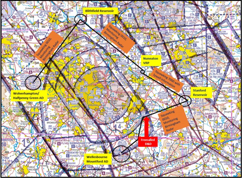
The account of the incident is the latest on the Airspace Safety Initiative (ASI) website. It took place last October on a flight from Halfpenny Green to Wellesbourne Mountford.
The route had been planned on a VFR 1:500,000 chart and a neat and comprehensive Pilot Log (PLOG) was produced using the methods taught on the navigation module of the PPL course.
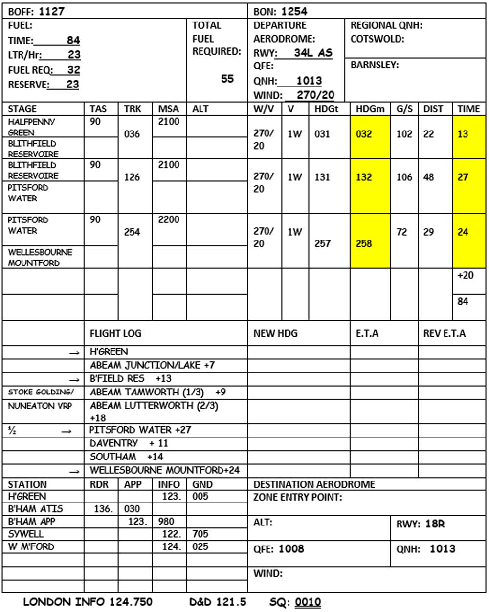
The student pilot produced a neat and comprehensive pilot’s log. Top: the pilot’s route
Prior to departure, the student pilot and instructor reviewed the plan and weather conditions. The reported conditions on that day seemed to be reasonable and the flight was authorised. They discussed using the Birmingham Frequency Monitoring Code of 0010 to allow for easier identification when flying close to Birmingham’s controlled airspace.
After departure, the pilot noted visibility was good but the wind was much stronger than expected. This resulted in some challenges to maintain headings and the vertical instability of the air meant it was difficult maintaining altitude.
Therefore, a large portion of time was spent on maintaining the heading and altitude leading to a significant increase in workload in flying the aircraft. It also resulted in calculated timings not being as accurate.
During the leg between Blithfield Reservoir and Pitsford Water, the pilot became uncertain of location and circled above Nuneaton VRP several times to establish a positive location fix.
Continuing on with the route, the pilot flew over a body of water (Stanford Reservoir) which he mistook for Pitsford Water.
When the pilot turned onto the heading for Wellesbourne Mountford it was made too early and that put him on track towards controlled airspace.
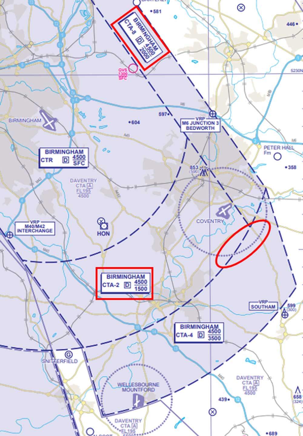
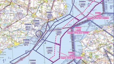
Where the student pilot infringed. Use of a moving map, as recommended by the CAA, might have helped avoid the incident. Images: ASI
The pilot realised he was flying in an area that did not correlate with the route plan and being unable to contact Birmingham, the pilot changed heading to south and called Distress and Diversion (D&D) on 121.500MHz.
D&D provided the pilot with a position fix and the pilot was able to navigate to Wellesbourne. On landing at Wellesbourne, the pilot immediately telephoned the instructor at Halfpenny Green and explained the enroute problems.
The ASI said the pilot had carried out good planning, building in prominent turning points and waypoints enroute. The route was to be flown 1,000ft above MSA which provided ample vertical separation from controlled airspace.
“In accordance with the Take 2 guidance (remaining 2nm laterally clear and/or 200ft vertically clear of controlled airspace) the planned route demonstrated text-book Threat and Error Management in this aspect,” added the ASI.
Crucially, the student pilot was not flying with a moving map. The use of a moving map had neither been taught in training nor encouraged.
The ASI points out that the CAA actively encourages all pilots to incorporate the use of moving maps in both pre-flight planning and in-flight. The Spring 2020 edition of TrainingCom states that it is important that instructors teach their students the use of GPS/GNSS aircraft systems when fitted to their aeroplane.
“The use of Moving Map displays should also be taught to enhance the student’s situational awareness once they have the basic Dead Reckoning (DR) navigation techniques,” continues the ASI.
“If the student uses these systems during solo-flying, this is permissible but they need to remember that they need to have the skills to later pass the licensing skills test.
“Therefore, it is the skills test that will be the time when the students DR Navigation techniques will be tested.
“Not only would a VFR Moving Map have provided the pilot with this enhanced situational awareness as they approached what they incorrectly thought was their turning point at Pitsford Water, but with a properly configured display, a visual and aural airspace warning would have been given alerting the pilot of their proximity to controlled airspace.
“In this occurrence, the pilot is to be commended for their handling of a stressful situation where an infringement was resolved in a timely manner.
“In addition, despite limited experience in the aviation community, the pilot carried out a detailed post-flight analysis including the submission of a detailed and honest report.”
Airspace Safety Initiative


10 comments
Air space is becoming extremely complicated squeezing traffic close to and below regulated airspace. The question that should be asked is how can we avoid this kind of situation by simplifying airspace and making it safer to ALL users.
You are so right, the controlled air space has just about made it impossible to fly any where in a straight line and a steady altitude,, some of the airspace grabs beggar belief !!
The pilot turned 10 minutes early (probably because they didn’t ‘stop’ the stopwatch whilst orbiting) and mid-identified the turning point. The complexity of airspace had nothing to do with it. (And this is not a complex bit of airspace). It was a simple loss of situational awareness regarding time and ground-to-map interpretation. I think they did an excellent job of getting themselves out of the pickle they found themselves in.
The problem is with flight information services in England.
In France FIS monitors all aircraft and warns if heading towards restricted airspace. Flying in England, the best you get 90% of the time is “basic service” which seems to mean buggah all.
Did he cause any ACTUAL problem for anyone? Or is this a bit like doing 80mph on an empty motorway?
I think this is a textbook case of update the syllabus. DR is important and a good skill but how many pilots actually use it now apart from in an emergency situation.
Like the comments say airspace is getting more complicated and if the use of GNSS is encouraged then I don’t understand why they syllabus isn’t updated accordingly.
This sort of occurrence happens to students during their training and usually, the weather is at fault most of the time. I’m certain the student had planned well and went through everything with their instructor before departing for their QXC. I believe incorporating a GPS/GNSS system would be beneficial to provide situational awareness and prevent infringement of airspace in the future.
DR is pre war and we have moved on but still needs to be there for when things go wrong but the use of skydemon and fourflight is the way forward I am teaching my students how to use one.
What worries me is that this instructor ‘discouraged’ use of a moving map. Whilst knowing how to do a bit of dead reckoning is obviously an advantage, *deliberately* choosing to fly without a moving map, especially around Birmingham, borders on recklessness. CAA need to have a word with any instructor who is encouraging students to do this. Whilst I appreciate that D&D never criticise anyone for getting themselves into trouble, no matter how stupidly, it’s almost like calling 999 because you’re lost.
Having recently (i.e in the last month) returned to GA I’ve got to say I was horrified when I saw the current half-mil chart (southern England). The controlled airspace is stupidly complicated and the way it’s depicted on the chart makes the chart all but useless for effective VFR navigation. Most of the useful navigation features are completely obscured by the CA markings. Apparently the use of sky-demon is about to be introduced into the PPL syllabus though.