Four locations have been identified as hotspots for infringements in the London Control Area (LTMA) in the latest narrative on airspace infringements in the UK.
The CAA says on the Airspace Safety website which hosts the narratives – 22 so far – that this is a timely reminder of the infringement risk when flying under or close to the London TMA.
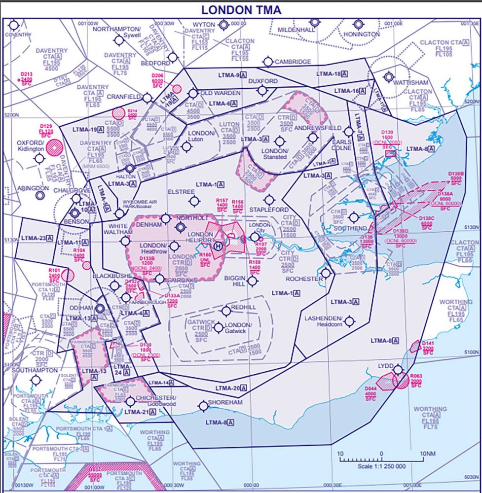
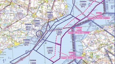
“For those not familiar with the airspace it comprises 24 different areas across a volume of airspace extending approximately 100nm from West to East and, in some areas 90Nnm from North to South.
“It encompasses the south-east of England from east of the Isle of Wight turning north just to the west of Dover, passing Southend, to the north-east of Clacton before turning west passing south of Cambridge towards Milton Keynes before turning south to the east of Oxford, east of Southampton and back to the Isle of Wight.
“The area overlays international airports, multiple civil and military aerodromes and private landing sites serving all aspects of aviation.
“The LTMA is Class A airspace with the lowest base in places as low as 2,500ft but the base levels rise further away from the centre and provides contiguous controlled airspace to the various Class D CTRs and CTAs for the London airports.
“In 2019 there were 279 reported infringements of the LTMA. An infringement of the TMA requires the ATCO to achieve 3nm or 3,000ft separation from the unknown infringing aircraft and invariably requires the issuing of ‘safety intervention measures’ such as avoiding action to known traffic to achieve separation.
“At first glance, the chart of the area looks complicated but careful planning before the flight, including formulating a ‘Plan B’ option, can assist with reducing the workload during the flight and the chance of an airspace infringement from occurring.
“Plan B should be an alternative route around controlled airspace when Plan A is denied due to traffic density or when the weather requires a track diversion.”
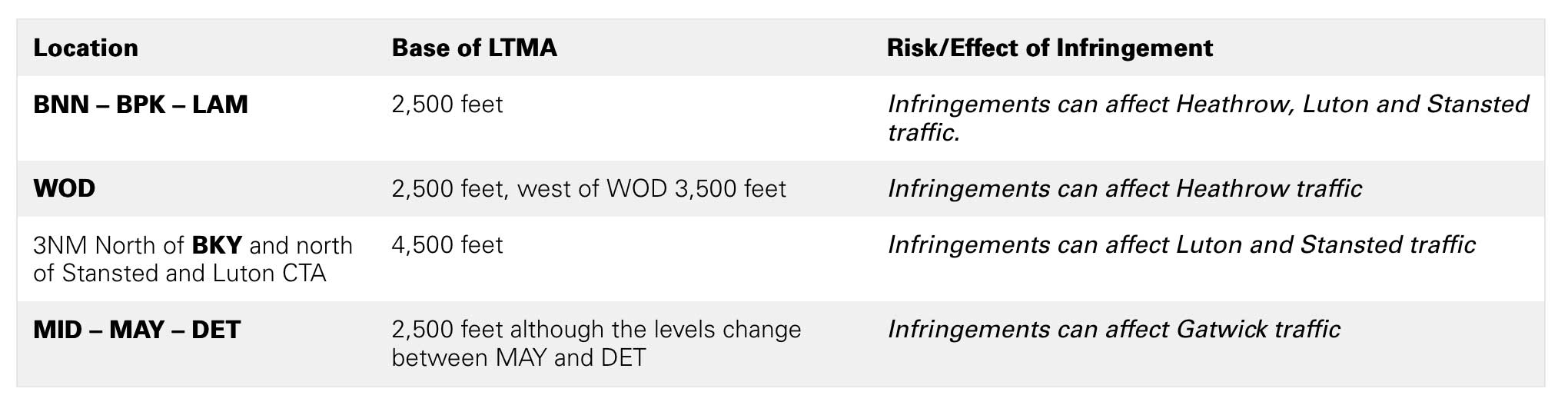
Hotspots
There are certain areas where infringements occur more often than others. A 5NM radius of the following areas are a general guide as to identified hotspots in respect of the TMA. Some of these infringements also result in infringements of adjacent CTAs.
The full article is here


6 comments
Call me curmudgeonly , but what a stupid map from the CAA! The text says there are 4 hotspots but does not show them on the map!
Even the link with ‘further information’ is unclear. All the CAA had to do was add green circles (or square or whatever) to the map to show these 4 hotspots – that would have been clear and simple to see. The information provided is not. With my eyesight and the scale of the map I can’t even see where BNN, BPK, LAM, WOD etc are – as far as I can tell the VORs are not even marked. I can’t be bothered to spend the time to get my charts out to work out where they mean; I suspect I am not alone in this.
Complete waste of time.
The Americans wouldn’t put up with this !
Literally a wholesale takeover of lower airspace, most of which is used for a minimal length of time. The prize examples are around those expensive little regionals like Southampton and Southend .
And don’t even mention Farnborough ! However they at least provide a decent radar service albeit with lots of unnecessary R/T now and, unfortunately, a definite change in attitude toward the light aircraft fraternity who dare to venture into their acres of new controlled airspace.
In terms of the whole SE corner of England, it’s not actually a large area to cover with specific, single frequency radar control as in the States.
More controllers and better equipment – but that would be too expensive. Easier just to deter the private pilot and hope that eventually he will just go away !
I believe that the unnecessarily complicated and oppressive airspace presented to VFR pilots is a big part of the infringement problem. It is difficult enough for local pilots, but I would not want to be visiting the UK and have to deal with our airspace. Every change seems to add more complication and inconsistency, not less. I know there’s a lot of work going on, but it seems that fundamental changes to the system are required. The extensive use of Class A is a prime example, giving no flexibility to VFR traffic.
We can do better.
I have to agree, its almost a “Gotcha”, with a little more thought it could have been valuable, but its nonsense.
Conceptually an interactive chart of some kind that allowed a maximum altitude to be entered could be a valuable tool for flight planning.
Set a maximum altitude of 2500 or 3000 feet and most of the clutter would disappear, making it easy to see where you *can* fly and enabling a route to be planned.
Maybe NATS could make a downloadable tool available?
Another possibility might be to make available a paper chart that only shows airspace below say 3000 feet, as an aid to navigating in the area and reducing airspace infringements. As there might be practical issues in producing and distributing a separate chart, such a chart might best be included as a supplement to the existing 1:500,000 Southern England chart.
A downloadable PDF version could also be made available that could be printed locally, although it would probably need to be printed in colour at A3 size to be useful, but if necessary two A4 sheets could probably be printed and joined.
There have long been examples abroad of charts that only show airspace below a certain altitude, and of separate charts for complex airspace, sometimes at a larger scale.