+VIDEO ForeFlight has just released the latest version of its flightplanning and navigation software which includes the ability to preview and ‘virtually fly’ a 3D Visual Approach to help brief an instrument approach.
There’s also a host of other upgrades including Mountain Passes and other Basemap elements and Quick-Access Airspace Frequencies.
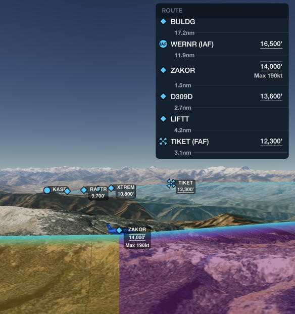
It has been said that one peek equals a thousand instrument cross-checks. Maps and charts tell a story about the approach, but it can be rather a rather abstract story at best.
ForeFlight’s 3d approach feature makes the story a movie, allowing you to easily visualise the whole flight in relation to the surrounding terrain. Using the altitudes from the flight plan and selected approach procedure, a realistic view of the flight is generated. Using the interactive navlog, the visualisation can be jumped to any leg of the flight.
The High Resolution Basemap includes mountain pass icons for the United States and Europe which are oriented based on their direction and also indicate the pass name and elevation in feet. The basemap in Europe depicts cables and gondolas as black line segments, with labels indicating each cable’s maximum above-ground altitude in feet.
ForeFlight’s Aeronautical Map has been expanded and now includes new Jeppesen VFR data covering Bosnia and Herzegovina, Serbia and Montenegro, Albania, Kosovo, and North Macedonia.
Additionally, quick access to frequencies associated with depicted airspace is now available with a “tap-hold” on any location on the map.
The 3D Preview feature is available to users on ForeFlight’s top of the range ‘Performance Plus’ subscription plan, while the remainder of the new features are available to all subscribers.